
Cambridge ZIP Code Coverage
Five ZIP codes appear on the City’s Cambridge ZIP map: 02138, 02139, 02140, 02141, and 02142. The area descriptions below are broad readings of that map and local geography, not USPS legal delivery descriptions. Every exact address should be checked with the current USPS lookup. Cambridge is compact, but one ZIP can cross several neighborhood labels, and one neighborhood can straddle more than one postal area.
| ZIP Code | Approximate Cambridge Area | Post Office Context | Record-Search Note |
|---|---|---|---|
| 02138 | Harvard and Old Cambridge, much of West Cambridge, parts of Baldwin and Neighborhood Nine. | Harvard Square Post Office context. | Verify the exact delivery ZIP before matching an address. |
| 02139 | Cambridgeport, The Port or Area Four, Mid-Cambridge, and central areas. | Cambridge station context. | Neighborhood boundaries do not match the ZIP edge. |
| 02140 | North Cambridge, Porter, and parts of Baldwin and Neighborhood Nine. | Porter Square Post Office context. | Delivery routes need address-level confirmation. |
| 02141 | East Cambridge, Wellington-Harrington, and the northern Kendall edge. | Cambridge USPS station and route context. | A city ZIP does not define a neighborhood. |
| 02142 | Kendall Square, Area 2 or MIT, and the eastern technology district. | Cambridge USPS station and route context. | Institutional and commercial addresses are common. |
The City ZIP map is dated January 2008, while the City’s open-data ZIP polygon layer was updated September 11, 2024. Both help with area context, but neither replaces the delivery result for a particular address. Postal geography changes for operational reasons, so retain the lookup date with any ZIP-based research note.
Cambridge ZIP Code Neighborhoods
Cambridge has 13 official neighborhood polygons: East Cambridge, Area 2 or MIT, Wellington-Harrington, The Port or Area Four, Cambridgeport, Mid-Cambridge, Riverside, Baldwin, Neighborhood Nine, West Cambridge, North Cambridge, Cambridge Highlands, and Strawberry Hill. Those civic geography labels are not a second ZIP system. They identify city planning and neighborhood context, while ZIP codes organize postal routing. A reliable address note can include both, as long as it does not turn a broad label into a boundary claim.
Cambridge’s neighborhood GIS layer shows the 13 official neighborhood polygons that differ from the City’s postal areas.
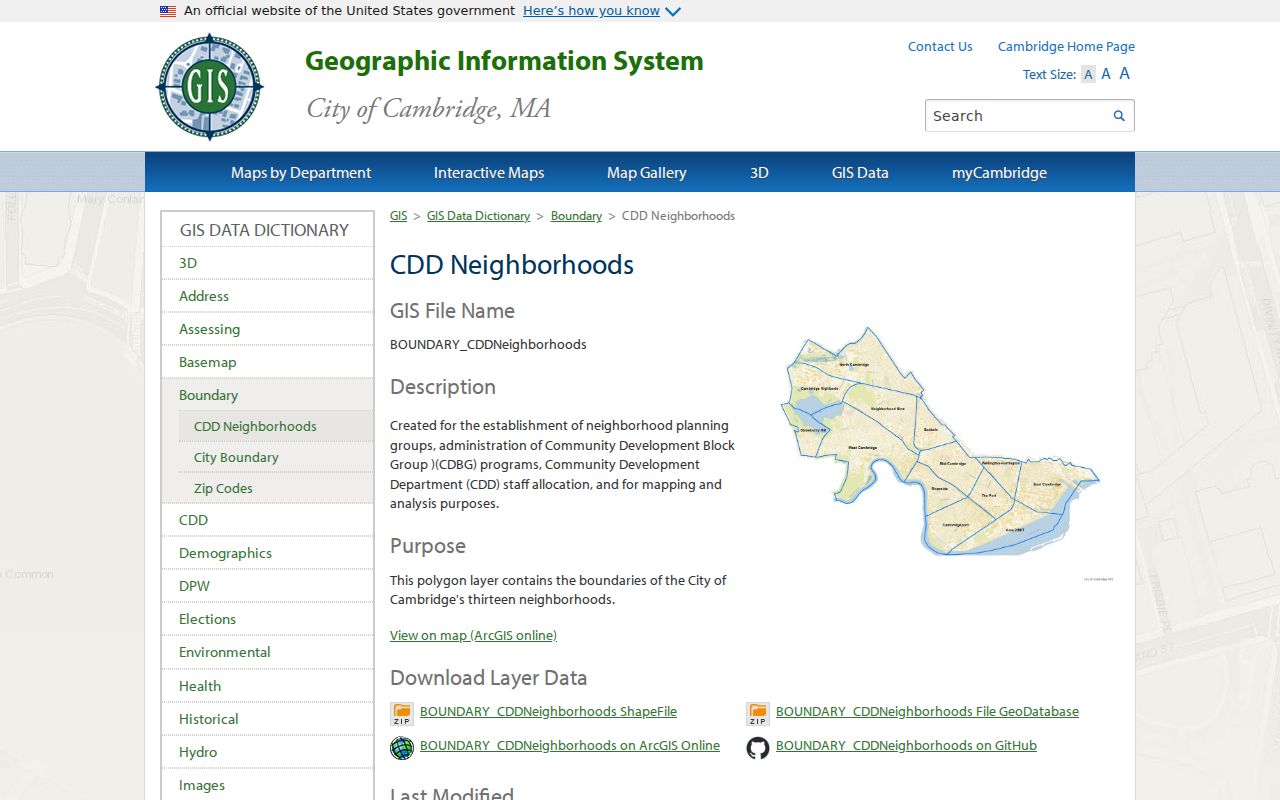
The displayed neighborhood layer supplies an important check on a ZIP code directory result. For example, a person may use a square or neighborhood name in an old directory or newspaper, while a current delivery address needs a street, unit, and ZIP. Use the square or neighborhood as a context clue, then validate the actual address with USPS and the City’s address tools.
Note: ZIP areas and neighborhood polygons answer separate questions, so record both labels only when each comes from its own source.
Cambridge ZIP Code Search Steps
There is no verified Cambridge ZIP-wide people search. The assessor’s visible controls are street, unit, property type, and advanced parcel, value, and sale fields, not a ZIP-only public browse. GIS can show ZIP polygons and select parcels spatially, but selecting a polygon does not produce a voter roster. The practical ZIP code directory workflow therefore checks a specific address first and uses a ZIP as a confirmation field or geographic filter, not as a stand-alone resident list.
- Use the USPS ZIP Code Lookup to verify the mailing form for the known street address, unit, city, and ZIP.
- Open myCambridge with that address to compare the City’s ZIP, neighborhood, assessing, historic, voting, and nearby-place context.
- Search the Cambridge Property Database by street number, street name, and unit to find the parcel and its assessed property context.
- Use the state voter confirmation only for a named person with a date of birth and residential ZIP. A lawful municipal-file request, where eligible, has separate conditions and is not a ZIP browse tool.
- When a ZIP has narrowed the place but the question is about a named street, use the Cambridge street directory method to review the address-keyed records.
This sequence keeps the postal, parcel, and voter systems in their proper roles. It also avoids treating an approximate map area as proof of a current connection to a particular building.
Cambridge ZIP Code Voter Check
The Cambridge Voter Registration Search directs users to the Massachusetts state service. It is a one-person confirmation tool. The statutory lookup asks for a name, date of birth, and residential ZIP, then returns registration or pre-registration status, active or inactive status, polling location, and elected officials. It is useful for verifying a candidate record after other research, but it does not reveal a public biography or provide a ZIP-wide roll.
| State Voter Field | Type | Role in the Lookup | Return or Limit |
|---|---|---|---|
| Name | Text | Identifies the voter or pre-registrant. | Required with the other inputs. |
| Date of birth | Date or text | Separates same-name records. | The public result does not display a full birth date. |
| Residential ZIP | Text | Confirms the address jurisdiction. | It is not a browse filter for all people in a ZIP. |
| Search | Action | Runs the candidate check. | Returns status, polling place, and officials. |
Massachusetts voter-file rules differ from the ordinary lookup. The Secretary describes public file fields and protected fields, while statewide lists have licensing and use limits. A ZIP, even when required for a person lookup, is not permission to create or redistribute a block-by-block list.
Cambridge ZIP Code Address Forms
One Cambridge location can have several valid address descriptions. A situs address identifies the physical parcel or building used by assessing, permits, GIS, and many code records. A mailing address identifies where a tax notice or other correspondence goes and can be outside Cambridge. A legal description identifies land through a deed, plan, lot, block, or metes-and-bounds language. The right one depends on the record keeper, so a ZIP code directory search should preserve the form shown by the source.
- ZIP code
- A postal routing code used with a delivery address. It does not establish city limits or a neighborhood boundary.
- ZIP+4
- An added four-digit delivery segment used to refine a ZIP code for a smaller delivery area or address group.
- PO-box ZIP
- A postal code associated with box service rather than a statement that every nearby physical address shares that route.
- Unique ZIP
- A ZIP assigned for a particular organization or delivery arrangement. It should be confirmed from USPS for the specific address.
- Carrier route
- A delivery route grouping used by postal operations. It is not a municipal district or a directory of occupants.
Cambridge’s master address database has been validated and reviewed through field checks over the past decade, and myCambridge is the practical address-normalization tool. The Election Commission also cautions that state voter address formatting must be followed. Harvard dorms use a special form with a zero street number and the dorm name, so a conventional numeric form may fail a voter-address check.
Cambridge ZIP Code Boundaries
ZIP code boundaries and Cambridge city limits serve different systems. A Cambridge mailing ZIP can sit near or across a city line, while a neighborhood can carry more than one ZIP. Institutional, commercial, university, and PO-box arrangements can route differently from a nearby physical address. Preserve the USPS-formatted address and the city and ZIP returned by the delivery tool rather than replacing it with a square or neighborhood name.
Boundary check. Use the City ZIP polygons for local geography and USPS for the current mailing address. Neither source creates a public list of residents within a ZIP.
The City’s 2008 map and the later open-data layer are evidence of mapped postal areas, not a current delivery promise. A property record uses situs and tax or mailing fields, a voter confirmation uses residential ZIP, and the Registry uses party, property, plan, book and page, or legal-description searches. A mismatch is often a clue to investigate, not an error to overwrite.
Cambridge ZIP Code Map Dates
Cambridge ZIP research should preserve the date of the map as carefully as the date of the record. The City’s ZIP map is dated January 2008, while its open-data ZIP polygon layer was updated September 11, 2024. Neither date is a delivery guarantee. They identify when the city made its boundary reference or polygon data available, not the date a postal route or individual mailing label became valid.
That distinction matters when comparing a directory, deed, permit, or voter result with an address from a different period. Keep the street form, unit, city label, ZIP, map source, and lookup date together. If an older record seems to use a different postal or neighborhood description, verify the full address before treating the mismatch as an error.
Cambridge ZIP Code Records Limits
A ZIP code directory can organize an address search, but it cannot settle identity or presence. The Cambridge assessor search has no inspected ZIP-only public browse mode and is not an owner-name tool. GIS polygons show geography, not private household membership. The voter lookup confirms one person at a time when all required inputs are supplied. Deeds document recorded interests, not every person associated with a property. These limits matter most in dense areas where a unit, a building, and a parcel may not point to the same record.
Cambridge’s local record geography can add another layer of confusion. Harvard Square, Porter Square, Central Square, Inman Square, Kendall Square, and East Cambridge can appear in a newspaper or historical directory even when a formal mailing address is absent. A square is a useful clue to a neighborhood and nearby cross streets, not a replacement for the street address or ZIP. Compare the source date, adjacent businesses or institutions, historic map, and later address record before assigning that reference to a particular parcel.
Cambridge’s five ZIP areas and 13 neighborhood polygons are a useful local comparison. The numbers reveal why a quick postal filter can be too broad for a historic directory, parcel, permit, or court question. Start with the exact address and source date, then keep a research log that distinguishes mailing, situs, legal, neighborhood, and ZIP labels. Public records should be used only for lawful personal, civic, or family-history research, never to stalk, harass, or harm anyone.
Note: When a result lacks a ZIP or returns a different one, verify the full address first before concluding that any record is wrong.